Natural Rivers, Green Corridors - Phase 2

Natural Rivers, Green Corridors - Phase 2

Natural Rivers Green Corridors (NRGC) 2 is the follow up project to the successful NRGC1 project that concluded in 2021. Our work in NRGC2 continues to focus on improving the condition of the Upper Rea Catchment, including the main River Rea and its tributaries (mostly the Bourn Brook).

The River Rea is one of three major Rivers in the Birmingham and Black Country, the others being the River Stour and the River Cole. The River Rea rises South of Rubery in Waseley Hills Country Park before flowing north through Longbridge, Kings Norton and Cannon Hill Park. From here it is largely culverted as it passes through Digbeth before joining the River Tame at Spaghetti Junction just after Star City. The Tame then flows into the Trent and finally into the Humber before reaching the sea on the East Coast.

The river is thought to have been instrumental in the creation of a settlement in the area. Dating back to the 7th Century, this provided a basis for Birmingham to build and develop throughout centuries, particularly during the industrial revolution. It was the industrial revolution that most heavily impacted on the natural state of the river, largely by manipulating river channels to serve mills and forges. 

Multiple organisations are now working together to help improve the condition of the river corridor and NRGC2 is no different. Whilst here at the Trust we are heading the delivery of the project, the Environment Agency are funding the four-year project until March 2027 and we are working closely with Birmingham City Council to enable delivery of individual projects on their land.

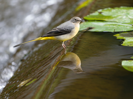
Grey wagtail on man-made weir

Adam Noon the catchment coordinator for the EA has said: “We are thrilled to continue our long-standing partnership with the Wildlife Trust by providing funding and technical guidance for the ongoing efforts to enhance and re-naturalise the Upper Rea catchment. The continuous restoration of this river system offers immense benefits and long-term effects on the area’s biodiversity and contributes to the climate emergency response. 

Re-naturalising rivers and watercourses is crucial for improving the environment. It helps slow the flow of water, reducing flood risks, and creates vital corridors for the migration of fish and other aquatic organisms. By restoring these natural processes, we enhance habitats for wildlife, supporting biodiversity and promoting healthier ecosystems."

Our main focus for this phase of the project is to continue minimising and mitigating the negative impacts of manmade interventions on the River. Such manmade interventions include; 

  1. canalisation (straightening of the channel);
  2. removal or of weirs and;
  3. removal of hard engineered banks (concrete, bricks or gabion baskets).

The project aims to re-naturalise the flow of the river as much as possible, and opening us several Kilometres of un-interrupted river corridor, whilst also considering the implementation natural flood management processes where possible. Works to enhance terrestrial habitats adjacent to the watercourse such as wetlands and woodlands are also being undertaken. 

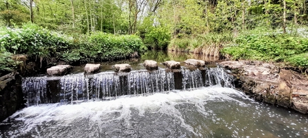
Man-made weir at King's Norton Nature Reserve

Man-made weir at King's Norton Nature Reserve

Our work to date includes weir removals at sites around Kings Norton and Lifford. So, what are weirs and why are we looking to remove them?

A weir is a structure built across a river or stream to control the flow of water, often by raising the water level or creating a pool for water storage or managing water flow. Weirs are usually made of concrete or stone, and they can serve purposes like flood control, water supply regulation, or even for purposes like creating small reservoirs for irrigation or recreational use. Many weirs we installed during the industrial revolution to help supply water to mills and forges along the river channel. 

Whilst, once thought to be effective tools for managing water flow, they can have significant negative impacts on rivers and their ecosystems. 

  1. Water Quality: Weirs can cause water stagnation in the areas behind them, reducing oxygen levels and increasing the risk of pollution build up. The slower-moving water behind a weir may not be as well-oxygenated, which is detrimental to fish and other aquatic life.
  2. Sediment Accumulation: Rivers naturally carry sediment downstream. When a weir is in place, sediment tends to accumulate behind it, disrupting natural sediment processes. This can lead to silt build up, upstream of a weir and to downstream areas having reduced sediment, which affects riverbed habitats and can make the riverbed erode over time.
  3. Blockage to migratory species: Many fish species rely on free-flowing rivers to migrate, breed, and access different habitats. Weirs can block these migrations, this is also true for invertebrate species.
  4. Erosion and Habitat Destruction: Weirs can cause erosion downstream as they alter the natural flow patterns. As sediment accumulates behind the weir and doesn't move downstream, the force of water can erode riverbanks and destroy habitats for plants and animals. It can also create deep scour pools where the power of the water over topping the weir structure.
  5. Flood Risk: In some cases, weirs are used to manage flood risk, but they can actually exacerbate flooding by concentrating water in certain areas and causing more severe downstream flooding when they are unable to handle sudden, high-volume flows (like during heavy rainfall).

Removal of the weirs allows the for natural river processes such as water flow, sediment transport, and nutrient cycling to re-establish, this helps to support healthy riverbeds, which in turn helps to support an increase range of flora and faunal species. It also allows for easier fish migration which is essential for breeding, feeding, and maintaining biodiversity. It's crucial for fish like salmon, trout and eel, which are currently either not present or present in low numbers in the catchment, which have specific migratory needs. We hope removal of these features helps towards the eventual return of these species in good numbers to the Upper Rea catchment. 

In some cases, removing weirs can help reduce the risk of floods by restoring natural river dynamics. When rivers are allowed to flow freely, they are better able to handle sudden surges of water, lowering the risk of catastrophic flooding downstream. All these changes benefit both the environment and communities that surround them.

In short, removing weirs helps to restore rivers to their natural states, benefiting ecosystems, improving water quality, and reducing flood risks, which is why there is a growing push to remove them, especially in areas where they are no longer serving their intended purpose.

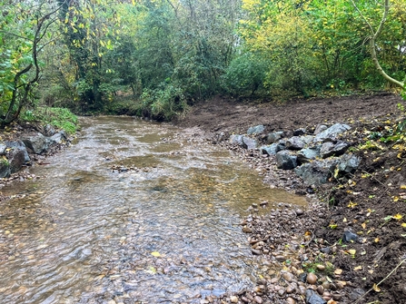
After weir removal at King's Norton Nature Reserve

After weir removal at King's Norton Nature Reserve

Whilst the areas that we have worked on will continue to settle into a natural flow regime, improvements can already be seen with reduce silt build up, variety in flow of the channel upstream of the weir location and wildlife making use of new habitat including birds such as wagtails been noted only a week after the works were completed. The areas will continue to be monitored moving forward, including invertebrate monitoring which will be done by the Trust but also by local ‘Friends of groups’. 

If you are keen in getting involved and helping us sample the river invertebrates to better understand the local water quality along the River Rea and River Cole, please contact Birmingham River Champions at birminghamriverchampions@gmail.com.  

Looking forward to the next couple of years, you might see us popping up across the region including at Pebble Mill, Northfield and Bourn Brook Walkway.  We will be continuing to remove more weirs, replacing hard engineered bank with natural banks where appropriate, planting up riparian and river banks areas, creating wet meadows and enhancing riparian habitats. 

All of this will help to improve the condition of the river corridor encouraging more wildlife and biodiversity into these valuable blue/green spaces. These corridors provide connectivity across an urban landscape which is becoming more crucial to climate change resilience as the temperatures increase. We are excited to be able to continue our work and to ensure the river corridors are in the best condition they can be, to support nature moving forward.